

Sileby History


Its people and places. A community through time.


Enclosure
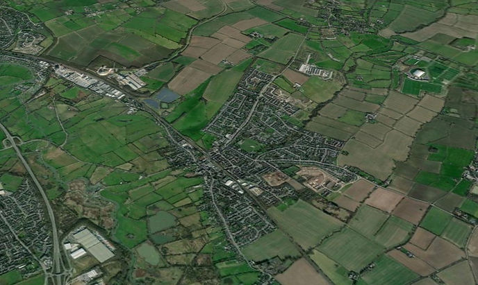
Sileby from the south west (© Google Earth)
The above photograph shows the parish of Sileby as it was in 2023. The village is surrounded by a myriad of fields and lanes. However, what is portrayed here is not a scene of continuous farming practice from time immemorial. Many of those fields and other features only came into being after the 30th June 1760; the day that the Sileby enclosure award was signed and sealed. It is not an exaggeration to say that the enclosure is one of the most significant events in the history and development of Sileby.
What is Enclosure?
In this case enclosure refers to the process whereby a part or the whole of the old open field (also known as common field) system of furlongs, numerous strips and communal farming was replaced by a wholesale re-allotment of the land redrawing the landscape into 'enclosed' allotments, plots and eventually fields, to be in private ownership.
There were several waves of enclosure activity both locally and nationally. Whereas the archetypal enclosure affected the whole of a parish or area, some places may experience piecemeal enclosure over a great length of time, sometimes centuries. Early enclosure (especially medieval and into the early modern period) is characterised by large and powerful landowners turning their open fields over to sheep runs and privately owned fields; it became a more economical way of farming to achieve maximum profits. This was often to the detriment of the local population whose livelihoods or rights were often disregarded, and could result in ejection and depopulation.
Another form was by the private agreement of landowners using the oversight of umpires. The enclosure of Cossington's open fields was achieved by this method in 1663.
From the early 17th century another route to enclosure was by a private Act of Parliament. After the 1750s, Parliamentary Acts became the standard means of achieving enclosure. Locally, 194 Parliamentary Acts were passed for Leicestershire between 1750 and 1801. They include:
Date of Award
1760
1761
1761
1763
1781
1782
Date of Act
1758-9
1758-9
1759-60
1762
1781
1781
Place
Sileby
Barrow upon Soar
Seagrave
Quorn
Mountsorrel
Rothley

MAP One - Sileby : Pre-1760 Common Field Landscape
Fields and Furlongs: Reconstructed from the Sileby Enclosure Preparatory Plan (ROLLR ref: MA/EN/A/292/1)
© Eric Wheeler 2010
Why the enclosure of Sileby took place
From the late 17th and early 18th century many Sileby farms had been sold to outsiders. This move saw the establishment of small landed estates, mainly owned by gentlemen and speculators. By the late 1750s Sileby’s landowners opted to enclose the village common fields largely as a result of influence from this landed interest.
Many enclosure bills, petitions and acts have the same preamble as to why enclosure was required. Sileby's enclosure petition says that the landowner's property was lying dispersed and intermixed in the fields and meadows of the parish, which was inconvenient for the efficient improvement of their farms and smallholdings. Their suggested mitigation would be for the agricultural landscape to be re-allotted into parcels, to be privately managed which would be "of great Advantage to the several Parties concerned." In other words, having their own allotments of land would enable them to farm efficiently due to being able to create sub-divisions and fields, decide on cropping, agricultural techniques and improvement. Many enclosers argued that having many strips or parcels of land dotted all over the parish was inefficient, time consuming and antiquated. Individual land improvements were difficult to attain in a communal farming economy.
Sileby's proprietor's also wanted to use the enclosure as an instrument to extinguish the ancient payment of tithes and other dues to the parish church. Compensation for their loss was given to the impropriator (the person who owned the right to levy the tithes) who took a seventh part of all other landowner's allotments in lieu of their former possession, all except the vicar who was exempt.

Ridge and Furrow - pre-enclosure landscape from the former Highgate Field (© Google Earth)
How it was achieved: Petition and Bill
At least 75% of the landowners of a parish or settlement had to agree to enclosure by Act of Parliament before the next stage could be considered. A petition outlining support and the reasons for Sileby's enclosure was brought before the Commons on the 29th January 1759, and a bill was presented a few weeks later on the 12th March. To become an act the bill was read three times and considered in committee (for alterations and amendments) in both House of Commons and Lords before gaining royal assent. All this was to occur within a single parliamentary session. The committee stages scrutinized the validity of the claims made in the bill, and to add amendments or to hear any opposition to it. According to the House of Commons journal, the owners of 274 acres (of the 2200 acres or so to be enclosed) in the parish did not agree to it, but no-one travelled to Parliament to argue their case. It was a fait accompli.
After going between committees and members in the Commons and the Lords, on the 24th April 1759 it was announced that the Lords had approved the bill with no amendments. The royal assent was finally given to the Act on the 2nd June 1759; the age of communal farming in the village was coming to a close.

Sileby Enclosure Act - Title page
Act to Award
The Act was the blueprint which gave the Award all the structure and permissions it needed to achieve the objectives of the enclosure. Firstly, commissioners were appointed to execute the terms of the Act and to formalise their decisions in a legally binding enclosure award. They were named as William Wyatt, Thomas Oldknow, John Watkinson, John Stone and Daniel Curwen. Their main role was to deliver a fair enclosure award; it was the final word on enclosure that 'set in stone' all the new allotments, measures and landowners rights. To achieve this, the commissioner's were to make a survey of the village and fields, to consider all claims to land and finally to redraw the village fields to accommodate all the authenticated claims. Decisions about public and private access to land, where roads should be (or newly constructed) and basic stipulations about the width and depth of watercourses were also made. In addition, they decided who was responsible for erecting fences and where fences were to be made, together with the proportions that each landowner would be assessed to pay for the enclosure, surveying, fees etc.
This mammoth task was completed and the Award was sealed and certified on the 30th June 1760. Proprietors were given 18 months to put the directions of the Award into effect.
Planning the changes: The Enclosure Survey Map

A large map (left) has survived in the record office at Wigston (ROLLR MA/EN/A/292/1), it is believed to be the enclosure survey map used to define the new landscape.
It is in fact two maps; one showing the former strips and open field landscape, and a second one with the new plots and roads superimposed over the former map to indicate the changes made and to show the landowners where their new plots will be.
It is the earliest surviving detailed plan of the whole parish. It dates from around 1758-9, the start of the enclosure process. It clearly outlines Sileby's open field structures and landscape, the five open fields and the two large areas of meadow. The village centre is also represented which includes one of the earliest depictions of the parish church.
Rumour has it that this important parish document was found in the roof of a barn, hence the poor state of survival of certain parts of it.

MAP Two - Sileby : Enclosure Award Land Allotments 1760
Reconstructed from the Sileby Enclosure Preparatory Plan (ROLLR ref: MA/EN/A/292/1)
© Eric Wheeler 2010
The Details of the Enclosure Award
Altogether the Commissioners awarded 2153 acres 2 roods and 7 perches between 66 owners. However, over 55% of the landed territory was made over to seven owners, four of which were non-resident. The impropriator William Pochin of Barkby received the greatest portion; his 414 a (acres) 3 r (roods) and 11 p (perches) included 45 acres for Glebe and 345 acres in recompense for losing the Great and Small Tithes.
Other non-residents include Thomas Wallis of Lincolns Inn who received 220a.1r.1p., and Elizabeth Sherrard and Margaret Molyneux, mother and daughter, who received 74a.3r.6p. and 148a.1r.7p. respectively. There was also a significant group of 20 owners allocated between 20 and 49 acres of land, nearly half of which (9) were non-resident. 39 owners made up the largest group being those receiving 20 acres or less. Of these, 20 (30% of the total) received less than 5 acres with the smallest being John Wilkinson with 5 perches.
The fencing of the new plots and the enclosure fees were borne by the new proprietors. Fees for the expense of gaining the Act, meetings, the survey and enclosing the vicar's plot came to over £880 (over £150,000 in todays reckoning) and were shared proportionately according the the value of the land allotted to each landholder. The vicar did not have to pay a penny. It impacted the smaller proprietors, who not only had to stump up money for the fees but also to financing the fencing of their new plots. They could neither refuse or obstruct the commissioners wishes who had legal authority to force the issue.
Two new roads were to be constructed, which later became Mountsorrel Lane and Seagrave Road.
There was no provision for the poor or for the Lord of the Manor.
To see a summary list of the 66 landowners and their allotments made under the award, click here

Seagrave Road - an 'enclosure' road with its hedges and ditches (2019)
Implications of the Sileby Enclosure Award
The Award effectively privatised the landscape outside of the village centre. It transformed the scene from its former open, communally farmed character to become a privately owned patchwork of hedged fields and farms. Those property boundaries forged by the Enclosure Award brings implications for development today; the blocs of land sold to developers are sometimes those same allotments that were created over 250 years ago, or whose limits are defined by those boundaries.
Seagrave Road and Mountsorrel Lane were built to solve the transport issues getting to Seagrave and Mountsorrel. They still form the main transport arteries to those places.
It has already been noted that over half the land to be enclosed had been awarded to seven people. William Pochin was the main beneficiary, he became the largest landowner almost overnight. His pre-enclosure 24 acre holding expanded to over 400 acres due to compensatory allotments made to him for the loss of tithes and glebe.
Landed proprietors could develop their new plots without the need to follow village rules on communal cropping and animal husbandry. Before enclosure, farms and smallholdings were based in the village centre. After enclosure a few landowners opted to construct farm units outside this area. Outlying farms such as Quebec, Hanover and Belle Isle were built in the midst of their new allotted fields in the half century or so after enclosure. Other lodges, farmsteads and smallholdings were to follow later. There was no doubt that enclosure increased agricultural yields and pushed development of agriculture through technical innovation. Landowners reaped the rewards through greater profits or higher rents for tenant farmers.
However, there were serious implications for the labouring poor. Pre-enclosure, the labouring poor had rights to use the common lands at certain times of the year, so that they could keep a cow or a few sheep to help feed the family or to sell. Likewise, age old activities such as gleaning at Lammas was important to supplement the family incomes and diet. Enclosure stripped away the common lands for re-allocation, removing a precious resource that the poor relied on. Unlike William Pochin and the vicar, the poor were not compensated for their 'losses'. Some parishes put aside a plot for the poor to have somewhere to grow food, but not at Sileby. As a result, some left the land altogether and headed off to the towns and cities. Those that were left led a tough existence, relying on farmers for work and/or on the parish for poor relief.
At its basic level, enclosure had become a land grab, forcing a wider gap between rich and poor. The 'problem' of the poor and underemployment were exacerbated by enclosure. In the early 19th century one Sileby farmer complained that his poor rate payment had increased so much that it equated to what the whole parish had formerly paid.
One surprising aspect of enclosure was the growth of land and property ownership in the parish. Normally, a concentration of land into fewer and fewer hands was the pattern seen in other parishes after enclosure. However, Sileby bucked the trend. Sileby's population often invested in property, or in land ownership allotment schemes popular after 1830. In 1773, small land holders made up only 19% of people paying the land tax in the village. By 1868, this figure had risen to 53%. It was a settlement of small freeholders which would have great impact on the future development of housing and industry in the village. For example, the different housing styles on Swan Street, Seagrave and Cossington Roads are mainly the result of the freeholders developing their own building plots to their own plans and specifications.